Gideon Weissman
Former Policy Analyst, Frontier Group
From South Padre Island to Galveston Bay, and from the San Marcos River to Lake Lewisville, Texas rivers, lakes and beaches draw thousands of people every time the sun is out and the temperature is up. But many of the waterways where Texans love to play are sometimes too polluted for people to go swimming, tubing, or wading safely. An analysis of water testing data from the Texas Commission on Environmental Quality (TCEQ) reveals that Texas beaches, rivers and lakes frequently exceed bacteria levels deemed safe under state law, indicating unsafe levels of fecal contamination.
Texans love the water – especially in the summertime. From South Padre Island to Galveston Bay, and from the San Marcos River to Lake Lewisville, our rivers, lakes and beaches draw thousands of Texans every time the sun is out and the temperature is up.
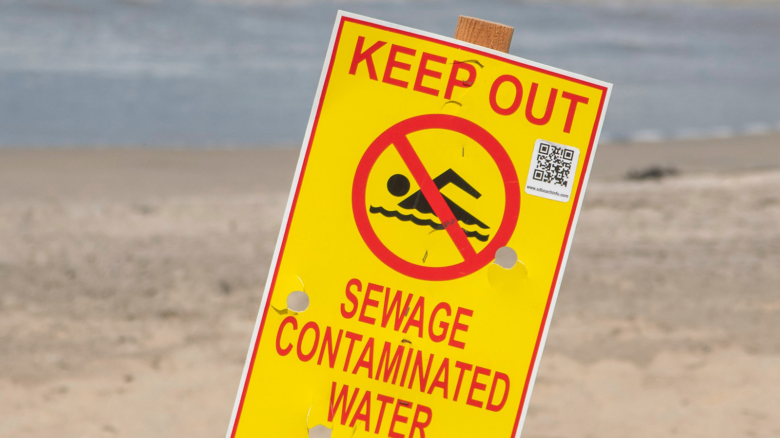
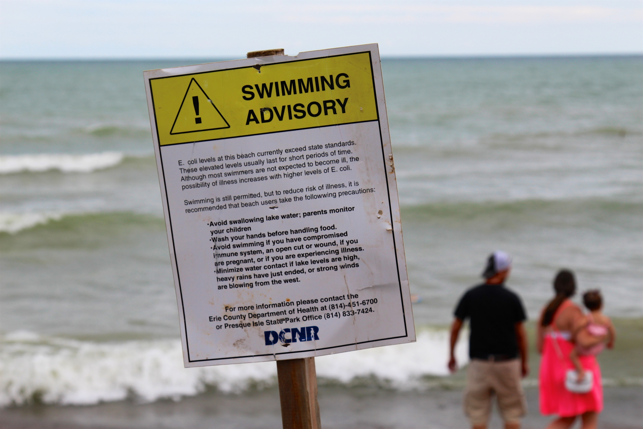
But many of the waterways where Texans love to play are sometimes too polluted for people to go swimming, tubing, or wading safely. An analysis of water testing data from the Texas Commission on Environmental Quality (TCEQ) reveals that Texas beaches, rivers and lakes frequently exceed bacteria levels deemed safe under state law, indicating unsafe levels of fecal contamination. Swimming in contaminated water can lead to gastrointestinal illness, as well as respiratory disease, ear and eye infections, and skin rashes.
To protect Texans’ health, and to ensure continued enjoyment of our waterways, Texas policymakers should undertake new efforts to limit water pollution.
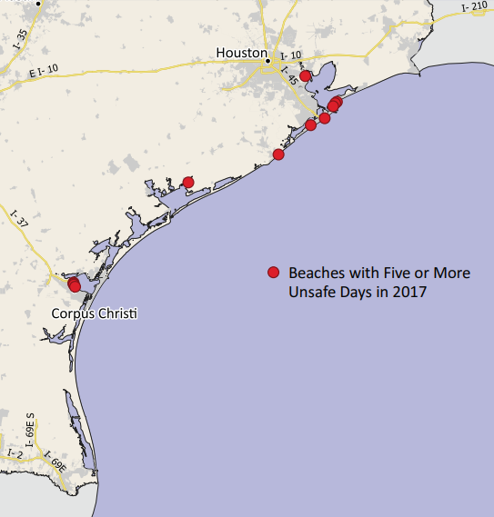
More than half of all Texas beaches that were tested for bacterial contamination were unsafe for swimming on at least one day during 2017. Among 120 beaches in the state, 75 were unsafe for swimming on at least one day when water was sampled. Over that period, each site was sampled an average of 39 times.
Table ES-1. Beaches with Five or More Days of Unsafe Water Pollution in 2017
For beaches with multiple testing stations, data from the station with most unsafe days is presented.
|
Beach Name |
Coastal Area |
Unsafe Days in 2017 |
Days with Sampling |
Percentage of Testing Days with Unsafe Water |
|
Ropes Park |
Corpus Christi Bay |
24 |
57 |
42% |
|
Cole Park |
Corpus Christi Bay |
20 |
53 |
38% |
|
Emerald Beach |
Corpus Christi Bay |
14 |
47 |
30% |
|
Galveston Island State Park #6 – Bayside |
Galveston Bay |
8 |
43 |
19% |
|
Rettilon Road |
Galveston Bay |
8 |
48 |
17% |
|
Magnolia Lane |
Galveston Bay |
6 |
43 |
14% |
|
Sylvan Beach – South |
Galveston Bay |
6 |
41 |
15% |
|
Beach Drive |
Freeport* |
5 |
41 |
12% |
|
Corpus Christi Marina – South |
Corpus Christi Bay |
5 |
41 |
12% |
|
Fort Crockett Seawall Park |
Galveston Bay |
5 |
41 |
12% |
|
Helen Blvd. |
Galveston Bay |
5 |
43 |
12% |
|
Palacios Pavilion East |
Matagorda Bay |
5 |
43 |
12% |
* In U.S. Geological Survey watershed maps, this area is referred to as the Austin-Oyster watershed.
Figure ES-1. Beaches with Five or More Days of Unsafe Water Pollution in 2017
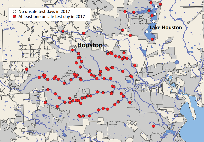
More than 700 freshwater sites tested as having levels of bacterial contamination that would have made them unsafe for swimming in 2017. Tests at 708 freshwater sites across Texas revealed levels of bacterial contamination that made them unsafe for swimming on at least one day during 2017, out of 1,450 freshwater sites tested. Many of these sites are not currently used for swimming, sometimes because of unsafe pollution levels.
Figure ES-2. In Houston Waterways, 96 out of 100 Test Sites Had Unsafe Bacteria Levels at Least Once in 2017
Urban and agricultural pollution are often to blame for unsafe water. The fecal contamination indicated by high bacteria levels comes from a range of sources – urban runoff carrying animal waste from pets; sewage overflows and septic leaks carrying human waste; agricultural runoff carrying livestock waste manure from industrial-scale feedlots; and all forms of runoff carrying animal waste from wildlife such as deer, feral hogs and seagulls.
Texans deserve access to clean, swimmable waters. But today, all too often, Texans looking to swim at the beach or tube down a river are deterred by warning signs – or worse, have their health put at risk. To keep Texas’ water safe, policymakers must take steps to test water quality at more locations, and test more frequently; post testing results and warnings more publicly; and prevent pollution at the source, whether from urban runoff, sewage systems, or agricultural runoff.
Former Policy Analyst, Frontier Group
Executive Director, Environment Texas Research & Policy Center
As the director of Environment Texas, Luke is a leading voice in the state for clean air, clean water, clean energy and open space. Luke has led successful campaigns to win permanent protection for the Christmas Mountains of Big Bend; to compel Exxon, Shell and Chevron Phillips to cut air pollution at three Texas refineries and chemical plants; and to boost funding for water conservation and state parks. The San Antonio Current has called Luke "long one of the most energetic and dedicated defenders of environmental issues in the state." He has been named one of the "Top Lobbyists for Causes" by Capitol Inside, received the President's Award from the Texas Recreation and Parks Society for his work to protect Texas parks, and was chosen for the inaugural class of "Next Generation Fellows" by the Robert S. Strauss Center for International Security and Law at UT Austin. Luke, his wife, son and daughter are working to visit every state park in Texas.